Soil - Definition
Soil is the topmost layer of the earth’s surface. It consists of a mixture of minute particles of disintegrated rocks, minerals, organic matter and bacteria. Soil is formed when forces of nature such as temperature, rain, wind, waves, animals and plants act on rocks and break them into tiny pieces over a long period of time.
Formation of Soil
Soil can be simply defined as a mixture of small rock particles/debris and organic materials/ humus which develop on the earth surface and support growth of plants.
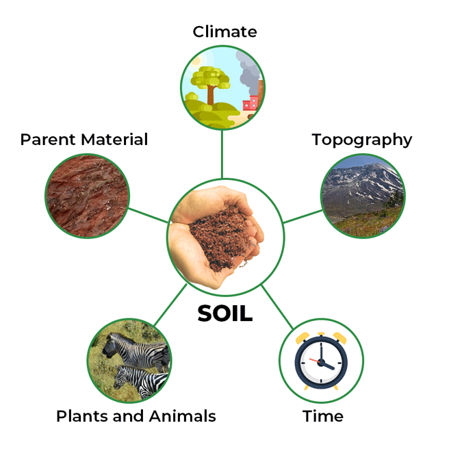
These are certain factors that affect soil formation:
- Parent Material
- Relief
- Climate
- Natural Vegetation
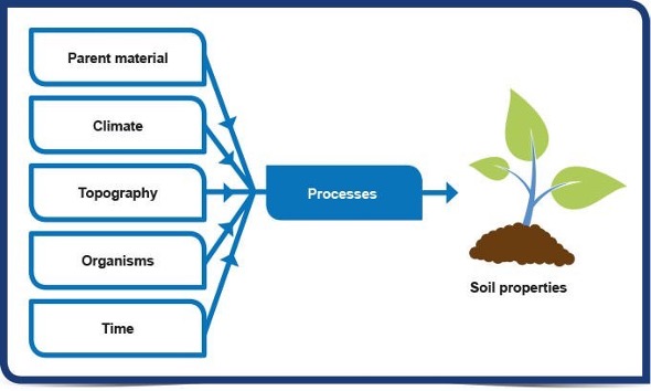
Parent Material
This is the material from which the soil has developed. The parent material can influence the soil in a number of ways: colour; texture; structure; mineral composition and permeability/drainage.
Climatic factors induce chemical changes which also affect physical properties of the soil. The surface rocks are exposed to the process of weathering. In this process, the rocks are converted into fine grains and provide a base for the soil formation.
In Indian Conditions, parent material is generally categorized into:
- Ancient crystalline and metamorphic rocks
- Cuddapah and Vindhyan rocks
- Gondwana rocks
- Deccan basalts
- Tertiary and Mesozoic sedimentary rocks of extra peninsular India {Rock System}
Ancient crystalline and metamorphic rocks: They are the Oldest rocks [(pre-Cambrian era)(formed due to solidification of molten magma about 4billion years ago)]. They form the ‘Basement Complex’ of peninsular India. They are basically granites, gniesses and schists. These rocks are rich in ferromagnetic materials and give rise to red soils on weathering. The red colour of these soils is due to the presence of iron oxide.
Cuddapah and Vindhyan rocks:They are ancient sedimentary rocks (4000 m thick). On weathering they give calcareous [containing calcium carbonate; chalky] and argillaceous [consisting of or containing clay] soils. The soil is mostly devoid of metalliferous minerals.
Gondwana Rocks: These rocks are also sedimentary in nature and they are much younger. On weathering they give rise to comparatively less mature soils. The soil is more or less of uniform character but of low fertility.
Deccan Basalts: Volcanic outburst over a vast area of the Peninsular India many hundred million years ago gave rise to Deccan Traps. Basaltic lava flowed out of fissures covering a vast area of about ten lakh sq km. Basalts are rich in titanium, magnetite, aluminium and magnesium. Consequently the weathering of these rocks has given rise to soils of darker color. The soil is fertile with high moisture holding capacity and is popularly known as ‘regur’ or black cotton soil.
Tertiary and Mesozoic sedimentary rocks: Rocks of extra peninsular (plains and Himalayas) India have given rise to soils with high porosity. These soils are generally immature recent and sub recent rocks, result in alluvial soils on weathering. Alluvial fertile soils consist of fine silts and clay. These soils have little relation with the original rocks.
On the other hand, the soils of peninsular plateau are generally coarse-grained and are closely related to the parent rocks. The peninsular soils are generally less fertile.
Relief
The relief is the most important factor for soil formation in places with steep slopes like the hilly regions, edges of plateaus etc. Soil erosion on barren slopes is rampant and it hinders soil formation. Example: Chambal ravines, higher reaches of Himalayas where there is minimal or no forest cover (most on the steep southern slopes) etc. The areas of low relief or gentle slope generally experience deposition and have deep soils. Example: Indo-Gangetic plain. The exceptions in the plateau are river basins where the soil layers are sufficiently deep.
In areas of heavy rainfall and high temperature, the soils are red or lateritic. Why?
Torrential rainfall during the rainy season washes the upper soil and leaches the materials into deeper horizon. During the dry summer season the evaporation exceeds precipitation and through capillary action iron and aluminium oxides are transported to the surface making the soil red. In areas of alternate wet and dry climate, the leached material which goes deep down in the horizon is brought up and the blazing sun bakes the top soil so hard that it resembles a brick. Therefore, this soil is called lateritic which literally means brick.
Natural Vegetation
Natural vegetation reflects the combined effects of relief and climate. The formation and development of soil is very much influenced by the growth of vegetation. The decayed leaf material adds much needed humus to soil thereby increasing its fertility. The densely forested areas contain some of the best soils in India. There is a close relationship between the vegetation types and soil types in India.
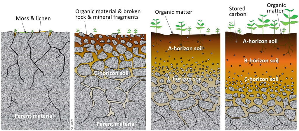
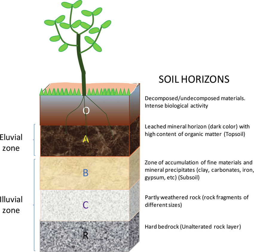
Soil Profile
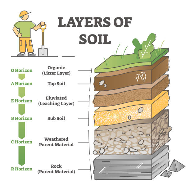
A vertical section through different layers of the soil is called the soil profile. A soil horizon is a layer generally parallel to the soil surface, whose physical characteristics differ from the layers above and beneath. Horizons are defined in most cases by obvious physical features, chiefly color and texture.
Soil formation begins with the breakdown of rock into regolith. Continued weathering and soil horizon development process leads to the development of a soil profile, the vertical display of soil horizons.
The top layer of the profile is the O horizon which is composed of organic matter. Decomposition of organic matter enriches the soil with nutrients (nitrogen, potassium, etc.), aids soil structure (acts to bind particles), and enhances soil moisture retention.
Next layer is the A horizon in which organic material mixes with inorganic products of weathering. The A horizon typically is dark coloured horizon due to the presence organic matter.
Eluviations, the removal of inorganic and organic substances from a horizon by leaching occurs in the A horizon due to the downward movement of soil water
The E horizon generally is a light-colored horizon with eluviations being the dominant process. Leaching or the removal of clay particles, organic matter, and/or oxides of iron and aluminum is also active in E horizon. The E horizon has a high concentration of quartz under coniferous forests, giving the horizon an ash-gray appearance.
The B horizon is a zone of illuviation where downward moving, especially fine material, is accumulated. The accumulation of fine material leads to the creation of a dense layer in the soil.
The C horizon represents the soil parent material, either created in situ or transported into its present location. Beneath the C horizon lays bedrock.
Eluviations are significant in humid climates where ample precipitation leads to the downward movement of minerals in the soil.
Illuviation are found closer to the surface in semiarid and arid climates where precipitation is scarce because due to capillary action cations like calcium and sodium dissolved in soil moves upward.
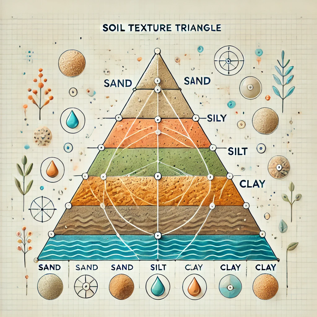
Soil Texture
Sandy Soil
Sandy soil is a light soil that consists mainly of sand, i.e., grains of quartz with considerable air spaces between them. The sand may either be ‘coarse’ where the particles are between 0.2 and 2 mm in diameter, or ‘fine’ where the grains between 0.05 and 0.2 mm are just visible to the naked eye. These light soils allow water to drain through rapidly, taking soluble plant foods with it. Sandy Soils are known as ‘hungry’ soils, which not only need constant manuring but may dry out completely during a period of drought so that shallow-rooted crops fail and pastures ‘burn’. They are good for horticulture (vegetables and fruits), legumes (such as moth and pulses), ground nut and bajra.
Clayey Soil
Clayey soil is an exceptionally fine grained soil, very retentive of moisture. It often becomes plastic when mixed with water. The individual grains of clayey soil are 0.002 mm in diameter. These particles consist mainly of hydrated aluminium silicates.
Clay contains little air and can hold more water, so forming a sticky mass, but when it dries out completely, it forms a hard, concrete like surface, seamed with numerous cracks. Sometimes, a compacted solid layer of clay in the subsoil is formed, which is known as clay pan, and is often hard and difficult to dig or plough. Clayey soils are often rich in plant food and give much better yields than that of sandy soils. They are devoted to rice; perennial grasses other crops such as clover. Efficient drainage methods, modern machinery and careful liming enable clayey soils to grow roots, green crops and cereals.
Silty Soil
Silty soil is finer than sand but coarser than clay. Its particles are assumed to have a diameter between 0.02 and 0.002 mm. These soils are rich in humus contents and are devoted to numerous cereal and non-cereal crops.
Loamy Soil
It is highly fertile soil consisting mainly of a mixture of sand and day, together with silt and humus. It has the good qualities of both sand and clay, but not their bad qualities. It comprises an almost equal mix of sand and silt with less than 30 per cent clay. It can retain some moisture and plant food even under the adverse weather and climatic conditions. It is well· aerated and drained, and can be readily worked. It is generally devoted to wheat, barley, legumes, sugarcane, sugar beet, maize, millets, rice, grasses, vegetables and orchards.
Major Soils in India
In India, soil had been classified from the ancient period itself even though it was not as detail as the modern classifications.
In the ancient period, the classification was based on only two things; whether the soil is fertile or sterile. Thus the classification was:
- Urvara [fertile]
- Usara [sterile]
Soil Classification – Agencies involved
In the modern period, when men started to know about the various characteristics of soil they began to classify soil on the basis of texture, colour, moisture etc.
When the Soil survey of India was established in 1956, they studied soils of India and their characteristics. The National Bureau of Soil Survey and the Land Use Planning, an institute under the control of Indian Council of Agriculture Research did a lot of studies on Indian soil.
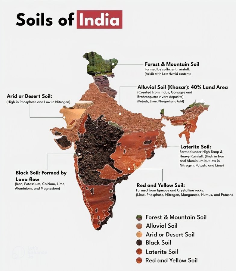
Major classification of Indian soils
- Alluvial soil [43%]
- Red soil [18.5%]
- Black / regur soil [15%]
- Arid / desert soil
- Laterite soil
- Saline soil
- Peaty / marshy soil
- Forest soil
- Sub-mountain soil
- Snowfield
Types of Soils |
States where found |
Rich in: |
Lacks in: |
Crops grown |
|
Alluvial |
Mainly found in the plains of Gujarat, Punjab, Haryana, UP, Bihar, Jharkhand etc. |
Potash and Lime |
Nitrogen and Phosphorous |
Large variety of rabi and kharif crops such as wheat, rice, sugarcane, cotton, jute etc. |
|
Black (Regur soil) |
Deccan plateau- Maharashtra, Madhya Pradesh, Gujarat, Andhra Pradesh,Tamil Nadu, Valleys of Krishna and Godavari. |
Lime, Iron, Magnesia and Alumina, Potash |
Phosphorous, Nitrogen and organic matter |
Cotton, sugarcane, jowar, tobacco, wheat, rice etc. |
|
Red |
Eastern and southern part of the deccan plateau, Orissa, Chattisgarh and southern parts of the middle Ganga plain. |
Iron and Potash |
Nitrogen, Phosphorous and humus. |
Wheat, rice, cotton, sugarcane and pulses |
|
Laterite |
Karnataka, Kerala, Tamilnadu, Madhya Pradesh, Assam and Orissa hills. |
Iron oxide and potash |
Organic matter, Nitrogen, Phosphate and Calcium |
Cashewnuts, tea, coffee, rubber |
|
Arid and Desert |
Western Rajastan, north Gujarat and southern Punjab |
Soluble salts, phosphate |
Humus, Nitrogen |
Only drought resistant and salt tolerant crops such as barley, rape, cotton, millets maize and pulses |
|
Saline and Alkaline |
Western Gujarat, deltas of eastern coast, Sunderban areas of West Bengal, Punjab and Haryana |
Sodium, Potassium, Magnesium |
Nitrogen and Calcium |
Unfit for agriculture |
Alluvial soil
- Mostly available soil in India (about 43%) which covers an area of 143 sq.km.
- Widespread in northern plains and river valleys.
- In peninsular-India, they are mostly found in deltas and estuaries.
- Humus, lime and organic matters are present.
- Highly fertile.
- Indus-Ganga-Brahmaputhra plain, Narmada-Tapi plain etc are examples.
- They are depositional soil – transported and deposited by rivers, streams etc.
- Sand content decreases from west to east of the country.
- New alluvium is termed as Khadarand old alluvium is termed as Bhangar.
- Colour: Light Grey to Ash Grey.
- Texture: Sandy to silty loam or clay.
- Rich in: potash
- Poor in: phosphorous.
- Wheat, rice, maize, sugarcane, pulses, oilseed etc are cultivated mainly.
Bhabar:
- The bhabar belt is about 8-16 km wide running along the Shiwalik foothills. It is a porous, northern most stretch of Indo-Gangetic plain.
- Rivers descending from the Himalayas deposit their load along the foothills in the form of alluvial fans.These alluvial fans (often pebbly soils) have merged together to build up the bhabar belt.
- The porosity of bhabar is the most unique feature. The porosity is due to deposition of huge number of pebbles and rock debris across the alluvial fans.
- The streams disappear once they reach the bhabar region because of this porosity. Therefore, the area is marked by dry river coursesexcept in the rainy season.
- The area is not suitable for agriculture and only big trees with large roots thrive in this belt.
Terai
- Terai is an ill-drained, damp (marshy) and thickly forested narrow tract(15-30 km wide) to the south of Bhabar running parallel to it.
- The underground streams of the Bhabar belt re-emerge in this belt. It is a swampy lowland with silty soils.
- The terai soils are rich in nitrogenand organic matter but are deficient in phosphate.
- These soils are generally covered by tall grasses and forests but are suitable for a number of crops such as wheat, rice, sugarcane, jute etc..
- This thickly forested region provides shelter to a variety of wild life.
Bhangar
- The Bhangar is the older alluvium along the river beds forming terraces higher than the flood plain (about 30 metres above the flood level).
- It is of a more clayey composition and is generally dark colored.
- A few metres below the terrace of the bhangar are beds of lime nodules known as “Kankar”.
Khadar
- The Khadar is composed of newer alluvium and forms the flood plains along the river banks.
- The banks are flooded almost every year and a new layer of alluvium is deposited with every flood. This makes them the most fertile soils of Ganges.
- They are sandy clays and loams, more dry and leached, less calcareous and carbonaceous (less kankary). A new layer of alluvium is deposited by river flood almost every year.
Red soil
- Seen mainly in low rainfall area.
- Also known as Omnibus group.
- Porous, friable structure.
- Absence of lime, kankar (impure calcium carbonate).
- Deficient in: lime, phosphate, manganese, nitrogen, humus and potash.
- Colour: Red because of Ferric oxide. The lower layer is reddish yellow or yellow.
- Texture: Sandy to clay and loamy.
- Wheat, cotton, pulses, tobacco, oilseeds, potato etc are cultivated.
Black soil / Regur soil
- Regur means Reguda(in Telugu) – best soil for cotton cultivation.
- Most of the Deccan is occupied by Black soil.
- Mature soil.
- High water retaining capacity.
- Swells and will become sticky when wet and shrink when dried.
- Self-ploughing is a characteristic of the black soil as it develops wide cracks when dried.
- Rich in:Iron, lime, calcium, potassium, aluminum and magnesium.
- Deficient in:Nitrogen, Phosphorous and organic matter.
- Colour:Deep black to light black.
- Texture: Clayey
Laterite soil
- Name from Latin word ‘Later’ which means Brick.
- Become so soft when wet and so hard when dried.
- In the areas of high temperature and high rainfall.
- Formed as a result of high leaching.
- Lime and silica will be leached away from the soil.
- Organic matters of the soil will be removed fast by the bacteria as it is high temperature and humus will be taken quickly by the trees and other plants. Thus, humus content is low.
- Rich in: Iron and Aluminum
- Deficient in: Nitrogen, Potash, Potassium, Lime, Humus
- Colour: Red colour due to iron oxide.
- Rice, Ragi, Sugarcane and Cashew nuts are cultivated mainly.
Desert / arid soil
- Seen under Arid and Semi-Arid conditions.
- Deposited mainly by wind activities.
- High salt content.
- Lack of moisture and Humus.
- Kankar or Impure Calcium carbonate content is high which restricts the infiltration of water.
- Nitrogen is insufficient and Phosphate is normal.
- Texture: Sandy
- Colour: Red to Brown.
Peaty / marshy soil
- Areas of heavy rainfall and high humidity.
- Growth of vegetation is very less.
- A large quantity of dead organic matter/humus which makes the soil alkaline.
- Heavy soil with black color.
Forest soil
- Regions of high rainfall.
- Humus content is less and thus the soil is acidic.
Mountain soil
- In the mountain regions of the country.
- Immature soil with low humus and acidic.
Saline and Alkaline
- In Saline and Alkaline Soils, the top soil is impregnated(soak or saturate with a substance) with saline and alkaline efflorescence (become covered with salt particles).
- Un-decomposed rock fragments, on weathering, give rise to sodium, magnesium and calcium salts and sulphurous acid.
- Some of the salts are transported in solution by the rivers.
- In regions with low water table, the salts percolate into sub soil and in regions with good drainage, the salts are wasted away by flowing water.
- But in places where the drainage system is poor, the water with high salt concentration becomes stagnant and deposits all the salts in the top soil once the water evaporates.
- In regions with high sub-soil water table, injurious salts are transferred from below by the capillary action as a result of evaporation in dry season.
Characteristics of Indian Soils
- In Saline and Alkaline Soils, the top soil is impregnated(soak or saturate with a substance) with saline and alkaline efflorescences (become covered with salt particles).
- Undecomposed rock fragments, on weathering, give rise to sodium, magnesium and calcium salts and sulphurous acid.
- Some of the salts are transported in solution by the rivers.
- In regions with low water table, the salts percolate into sub soil and in regions with good drainage, the salts are wasted away by flowing water.
- But in places where the drainage system is poor, the water with high salt concentration becomes stagnant and deposits all the salts in the top soil once the water evaporates.
- In regions with high sub-soil water table, injurious salts are transferred from below by the capillary action as a result of evaporation in dry season.
Problems of Indian Soils
Soil erosion (Himalayan region, Chambal Ravines etc.), deficiency in fertility (Red, lateritic and other soils), desertification (around Thar desert, rain-shadow regions like parts of Karnataka, Telangana etc.), waterlogging (Punjab-Haryana plain) salinity and alkalinity (excessively irrigated regions of Punjab, Haryana, Karnataka etc.), wasteland, over exploitation of soils due to increase in population and rise in living standards and encroachment of agricultural land due to urban and transport development.
Soil Erosion
‘Soil erosion’ has been defined as the gradual removal of the top soil by running water, wind, glacier, sea-waves, anthropogenic agents and animals.
– Soil erosion is a universal phenomenon.
– According to one estimate about 75, 000 million tones of soil is removed by these agents annually.
Types of soil erosion
Normal erosion: This is caused by the gradual removal of topsoil by natural processes. The rate of erosion is slow.
Accelerated erosion: This is caused by manmade activities. In this case, the rate of erosion is much faster than the rate of formation of soil.
Causes of soil Erosion
Running water:
a) Uniform removal of soil
b) Rill erosion
c) Gully erosion (e.g. northern Punjab, Haryana, Rajasthan, M.P. U.P)
Wind Erosion: Mainly in the arid and semi -arid regions.
Anthropogenic factors: Farmland can be degraded in several other ways besides erosion. Physical degradation from mechanical tilling can lead to compaction and crusting. Repeated cropping without sufficient fallow periods or replacement of nutrients with cover crops, manure or fertilizer can deplete soil nutrients. In addition over application of chemical fertilizers, insecticides and pesticides can kill beneficial soil organism.
– Poor water management on irrigated crop land is a leading cause of degraded farmland.
– Inadequate drainage can lead to water logging of the soil or to Salinization, in which salt levels built up in the soil to toxic levels. About 15 to 20 percent of the irrigated land is suffering from some degree of water-logging and salinization.
Biotic agents: Overgrazing, mining and deforestation are the major biotic agents causing soil erosion. These processes disturb the top soil thereby exposing the soil to various physical forces inducing erosion.
Landslides cause soil erosion: Construction of dams, buildings and roads removes the protective vegetal cover leading to soil erosion.
Deforestation:
‘Deforestation’ is the conversion of forest to another land use or the long-term reduction of tree canopy cover below the 10% threshold. Deforestation defined broadly can include not only conversion to non-forest, but also degradation that reduces forest quality – the density and structure of the trees, the ecological services supplied, the biomass of plants and animals, the species diversity and the genetic diversity. Deforestation includes cutting and felling of trees, removal of forest litter. Browsing and trampling by livestock, forest fires, also leads to cause deforestation etc. Deforestation leads to erosion. Deforestation further leads to land degradation, nutrient and the disruption of the delicate soil plant relationship.
Over grazing:
- During the rainy season, there is plenty of vegetation and animals get enough fodder.
- But during the dry period, there is shortage of fodder and the grass is grazed to the ground and torn out by the roots by animals.
- This leads to loose structure of the soil and the soil is easily washed away by rains.
- Moreover, soil is pulverized (reduce to fine particles) by the hoofs of animals, and thus proves detrimental to top soil when heavy showers fall on it.
- Soil erosion due to overgrazing is a common site in the hilly areas.
Harmful Effects of Soil Erosion
Loss of fertile top soil leading to gradual loss of soil fertility and agricultural productivity. Loss of mineral nutrients from soil through leaching and flooding.
Loss of soil ability to hold water and sediment. Sediment runoff can pollute water courses and kill aquatic life. Lowering of the underground water table and decrease in the percentage of soil moisture. Drying of vegetation and extension of arid lands.
Increase in frequency of droughts and floods. Silting of river and canal belts.
Recurrence of landslides. Adverse effect on economic prosperity and cultural development.
Extent of Soil Erosion in India
80 million hectares or about one-fourth of our total area is exposed to wind and water erosion. One-eighth of land has undergone serious erosion. Wind erosion is a serious problem in arid and semi-arid parts of north-west India. About one-ninth of land is subject to severe wind erosion in Rajasthan and adjoining areas of Punjab, Haryana, Gujarat and Western Uttar Pradesh. It is estimated that 34 lac tones of fertile soils is removed by wind every year. The loss due to water erosion is 53.34 million hectares annually.
Lack of proper agricultural methods:
Much of the soil erosion in India is caused by faulty methods of agriculture. Wrong ploughing, lack of crop rotation and practice of shifting cultivation are the most adversely affecting methods of agriculture. If the fields are ploughed along the slope, there is no obstruction to the flow of water and the water washes away the top soil easily. In some parts of the country, the same crop is grown year after year which spoils the chemical balance of the soil. This soil is exhausted and is easily eroded by wind or water. Shifting cultivation practiced in some areas in the north-eastern states. In this method, a piece of forest land is cleared by felling and burning of trees and crops are grown. The removal of the forest cover leads to the exposure of the soil to rains and sun which results in heavy loss of top soil, especially on the hill slopes.
Effects of Salinity and Alkalinity
- In Saline and Alkaline Soils, the top soil is impregnated(soak or saturate with a substance) with saline and alkaline efflorescence (become covered with salt particles).
- Un-decomposed rock fragments, on weathering, give rise to sodium, magnesium and calcium salts and sulphurous acid.
- Some of the salts are transported in solution by the rivers.
- In regions with low water table (due to over irrigation in canal irrigated areas), the salts percolate into sub soil and in regions with good drainage, the salts are wasted away by flowing water.
- But in places where the drainage system is poor, the water with high salt concentration becomes stagnant and deposits all the salts in the top soil once the water evaporates.
- In regions with high sub-soil water table, injurious salts are transferred from below by the capillary action as a result of evaporation in dry season.
- In canal irrigated areas plenty of the water is available and the farmers indulge in over irrigation of their fields.
- Under such conditions, the ground water level rises and saline and alkaline efflorescences consisting of salts of sodium, calcium and magnesium appear on the surface as a layer of white salt through capillary action.
- Alkalinity implies the dominance of sodium salts, specially sodium carbonate.
- Although salts of alkali are somewhat different in their chemical properties from the salts of saline soils both soils occur in the same areas.
- Sandy soils are more prone to alkalinity and the loamy soils to salinity-alkalinity.
- It is estimated that about 80 lakh hectares of land (2.43% of the country’s total area) is affected by the problem of salinity and alkalinity.
- Vast tracts of canal irrigated areas in Uttar Pradesh. Punjab and Haryana; arid regions of Rajasthan, semi-arid areas of Maharashtra, Gujarat, Andhra Pradesh, Telangana and Karnataka etc. are facing this problem.
- Although Indira Gandhi canal in Rajasthan has turned the sandy desert into a granary, it has given birth to serious problems of salinity and alkalinity.
Desertification
Desertification refers to degradation of land in arid, semi-arid, and dry sub-humid areas due to an array of factors. The direct impact of desertification is reduced biodiversity. The reasons are many such as climatic changes such as drought, or human such as overgrazing. Desertification is recognized as a major threat to biodiversity and consequently leads the countries to develop plans to counter its impacts.
Measures to Control Desertification
- Intensive tree plantation in the transition zones.
- Mulching shifting sand dunes in deserts with different plant species. Mulches serve as an effective physical barrier to the moving sand.
- Grazing should be controlled and new pastures should be developed.
- Indiscriminate felling of trees should be banned.
Ecological implications of desertification are as follows
- Drifting of sand and its accumulation on fertile agricultural land.
- Excessive soil erosion by wind and to some extent by water.
- Deposition of sand in rivers, lakes and other water bodies, thereby decreasing their water containing capacity.
- Lowering of water table leading to acute water shortage.
- Increase in area under wastelands.
- Decrease in agricultural production.
- Increase in frequency and intensity of droughts.
Measures of Controlling Desertification
- Intensive tree plantation programme should be initiated.
- Mulching the shifting sand dunes with different plant species serves as an effective physical barrier to the moving sands.
- Grazing should be controlled and new pastures should be developed.
- Indiscriminate felling of trees should be banned:
- Alternative sources of fall can reduce the demand for fuel wood.
- Sandy and wasteland shuld be puit to proper use by judicious planning.
Water logging
Water logging refers to the saturation of soil with water. Soil may be regarded as waterlogged when the water table of the ground water is too high to conveniently permit an anticipated activity, like agriculture. Crops need air to a greater or lesser depth in the soil. If there is no proper drainage system in the land, the land will become waterlogged.
This results in the saturation of crops. The normal circulation of air will not be possible due to water logging and the amount of oxygen in the soil will decline. Construction of proper drainage system to allow water flow away from the land is the best way to reduce water logging.
Soil Conservation
“Soil conservation is the prevention of soil loss from erosion or reduced fertility caused by over usage, acidification, salinization or other chemical soil contamination. Slash-and-burn and other unsustainable methods of subsistence farming are practiced in some lesser developed areas.
Soil conservation methods
- Contour ploughing (cultivation against the direction of the wind).
- Strip cultivation (cultivation in strips).
- Flood control by government initiatives.
- Reclamation of Bad Lands.
- Wind breaks in land; like trees at borders.
- Organic farming.
- Control/restrict shifting cultivation.
- Construction of proper drainage.
- Leveling of gullies, ravines etc.
- Control of chemical fertilizers and pesticides in the market.
- Proper awareness about the need of conservation.
